Our Country's Fiery Ordeal

A blog about the American Civil War, written and maintained by historian Daniel J. Vermilya, author of The Battle of Kennesaw Mountain (History Press, 2014) and James Garfield and the Civil War (History Press, 2015)

Dedicated to my great-great-great grandfather, Private Ellwood Rodebaugh, Company D, 106th Pennsylvania Volunteer Infantry, killed at the Battle of Antietam, September 17, 1862.

"And may an Overuling Providence continue to cause good to come out of evil, justice to be done to all men where injustice has long prevailed, and finally, peace, quiet, and harmony to come out of this terrible confrontation and our country's fiery ordeal." -- Albert Champlin, 105th Ohio, Diary entry of June 19, 1864 (Western Reserve Historical Society)

Saturday, March 23, 2013

The Roulette Farm: The Panorama View

Earlier this month, we looked at the terrain of the Mumma farm from a panorama view. Today, we will look at the Roulette farm; primarily, we will be focusing on the approach of French and Richardon's divisions in their assault on the Sunken Road. For those who didn't read the previous post, please check it out at the link above. It goes hand in hand with today's post.


This panorama shot shows the ground over which men of William French's and Israel Richardson's divisions advanced on the morning of September 17, 1862. These two divisions had been separated from John Sedgwick's division of the Second Corps due to terrain, orders, and confusion (this is discussed more in the previous post). On the far left of the photograph, the Observation Tower on the Sunken Road can be seen. On the far right, there is the Roulette Farm. This picture was taken from one of the highest ridges on the ground over which these Federal soldiers advanced. They moved across this ground from right to left in this photograph.


In this version of the Ezra Carman map showing troop movements from 9 am to 9:30 am, several features are highlighted. First, the spot where the panorama was taken is noted by an orange star. The observation tower is indicated by a tall red pyramid, helping to show where the left edge of the image is located. The Roulette farm, on the right of the panorama, is circled in red. The location of the Visitor Center is circled in yellow, and the Reel Ridge in the far distance of the panorama is highlighted in light blue. Additionally, the trees along the Roulette farm lane, visible in the center of the panorama photograph, are highlighted by a green line in the map above. I thought these enhancements would help interpret the map and the photos together, especially for those who aren't terribly familiar with the terrain and location.


The reason why this photograph is so telling is it shows something vitally important about the Sunken Road attack. This terrain, like much of Antietam, is an ocean of hills, ridges, swales, and depressions. This terrain was one major reason why the killing and slaughter was so great that day. From this position, only parts of the Sunken Road can be seen, making it a hidden trench of sorts. However, Federal soldiers would have been open to artillery fire from the Piper Farm behind the Sunken Road and, more importantly, from the Reel Ridge. While the Piper Farm is hidden from view, the Reel Ridge is just under one mile away. It was covered with Confederate artillery and able to blast Union soldiers advancing on the Sunken Road. While we often discuss the view Confederate soldiers in the road had of advancing Federals, we often forget that those Federals were exposed to artillery fire throughout the assault. 

Essentially, the views for advancing soldiers were changing with every step they took. While this may seem an obvious point, it is much more relevant when considering that the lines of sight are changing, affecting the vulnerability of attacking soldiers to rifle and artillery fire.


Here are a few more specific shots of the terrain:


This picture, taken from behind the Roulette Farm, is looking toward the Sunken Road and the Observation Tower, visible in the distance. While the trees in the foreground were not present in 1862, they don't take away from what the image tells us; from this position, seeing and understanding the strength of Confederates in the road was a near impossibility due to the terrain.


 This image was taken from the same vantage point as the panorama photograph, and is looking toward the Roullette farm (the right side of the panorama)


 This image was also taken at the same point as the panorama. It is looking toward the hill on which the visitor center currently sits.


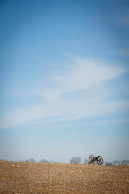
This image, taken from the spot of Graham's battery, is near the site of the previous two pictures. It shows how close they were to the Observation Tower. 


Image of the view Graham's battery would have had in responding to Confederate fire on the Piper Farm (invisible from this spot due to terrain) and the barely visible Reel Ridge in the distance.


A better image showing that most of the Sunken Road is barely visible from this spot. In the distance is Reel Ridge, which was covered by Confederate artillery pieces firing into the ranks of oncoming Union soldiers in French's and Richardson's divisions.

Friday, March 22, 2013

The Future of Civil War History Conference

Now that I'm back in Ohio from my trip to Maryland and Pennsylvania, I wanted to do a post about the Future of Civil War History Conference which I attended at Gettysburg College last weekend. It was a great conference with lots of interesting panels. I found a number of them very interesting, especially those on discussing emancipation with visitors, the presentation on how to incorporate sights and smells of the battlefield into interpretation, and a discussion on uses of new media in Civil War History.


Hands down the best program of the weekend was led by Scott Hartwig and Peter Carmichael. It was on Saturday afternoon when the temperatures were in the mid 30s with driving rain and sleet. I know, sounds fun, right? The program was a walk of Pickett's Charge (I have NEVER walked the field in those conditions before, so it was illuminating from that perspective alone). The focus was on new interpretive possibilities of Pickett's Charge. So, not only did we talk about the charge itself but new stories that illustrate various soldier and civilian experiences that can normally fall by the wayside in traditional battlefield interpretation. It was the most informative and helpful program of the weekend.


However, while I enjoyed the conference, at nearly every one of the individual discussion groups, there was at least one speaker who made it clear that he or she was not a Civil War historian but rather a social media expert, a communications expert, or a social historian (just a few examples). It seemed as though many of the presenters had only been to Gettysburg (or any battlefield) perhaps once or twice before, and even then maybe not in any capacity other than taking the basic battlefield tour.


This ended up being problematic on some of the panel discussions. There were scholars who were not familiar with Civil War battlefields discussing how to interpret Civil War battlefields. Many were entirely unaware of how programs work at NPS sites and what visitors at those sites are like. I heard it said numerous times that visitors to Civil War battlefields are thirsting for more discussion of emancipation, civilians, and gender history. That could not be any further from the truth. By and large, visitors avoid those programs like the plague. They want battle stories. That is what makes doing battlefield interpretation so difficult. We have to give the people what they want while still educating them about other important aspects of the Civil War that they may not know about.

That was, as I understood it, one of the purposes of the conference: to bridge the divide between academic historians and public historians to figure out how to interpret better Civil War history sites.

Perhaps the biggest thing I learned at the conference is that sites like Antietam National Battlefield are doing exactly what they should in leading the way for the next wave of Civil War history. Antietam now has a park blog, uses facebook and twitter accounts to reach people, and focuses on emancipation as one of the main interpretive themes of the park. I am very proud to work there and call the rangers on the interpretive staff there my colleagues, and I look forward to all of the great programs that we will offer in the year ahead.

While I found the disconnect between some of the presenters and the reality of battlefield interpretation frustrating at times, I still greatly enjoyed the conference because if anything it reinforced my feelings on the direction of Civil War history. Civil War historians do need to include more discussion of emancipation, African Americans, civilians, and women into their presentations, especially in the National Park Service. It was good to see that discussed in a meaningful way. 

I think the best part of the conference was bringing together academic professors and public historians to discuss the field of Civil War history together. Peter Carmichael and his staff at Gettysburg College did a fantastic job with the conference, and I think it was overall a very productive experience.

Wednesday, March 20, 2013

Emancipation Program for the Lake County Bar Association Literary Committee

For those in the Painesville, Ohio, area tomorrow, and who are willing to brave the several inches of lake effect snow that the forecasts are calling for, I will be speaking to the Lake County Bar Association's Literary Committee at the Lake County Court House in downtown Painseville at 4:45 pm. The topic of the program will be Lincoln's Emancipation Proclamation. The program is open to the public, and we will be meeting in Judge Culotta's courtroom on the first floor of the building.


If you can make it for the program, I look forward to seeing you tomorrow afternoon in Painesville.

Friday, March 15, 2013

Gettysburg Conference Day 2: Sunrise and Sunset

Today was day 2 of the Civil War Institute conference on the future of Civil War history in Gettysburg. It was a great day of lectures and discussions. Some very interesting themes and questions are developing. Among these are how different NPS sites interpret the battles or history that occurred there, as well as how to incorporate monuments and emancipation into battlefield interpretation in ways that will engage the next generation of historians. I will share more on here when the conference wraps up.


For now, enjoy what today's sunrise and sunset looked like from Gettysburg...


Sunrise from the Virginia Monument on Confederate Avenue this morning...


Sunset from Cemetery Ridge, with the marker indicating where Major General Winfield Scott Hancock was wounded on July 3, 1863, in the foreground...


Thursday, March 14, 2013

Live From Gettysburg...

Today I arrived in Gettysburg for the start of the Gettysburg College Civil War Institute's conference on the Future of Civil War history. The conference runs through Saturday and features academic and public historians discussing various ways to reach new generations with Civil War history in a meaningful and engaging manner.

The opening panel discussion was misconceptions on Civil War military history, and it was quite interesting. Some of the misconceptions discussed included how tactics affected casualties, the question of whether the Civil War was a "total war", and how West Point theories affected Civil War battles.

I look forward to posting about and discussing some of the things discussed at the conference on here in the near future. 


Wednesday, March 13, 2013

The Mumma Farm: The Panorama View

This past Saturday morning I spent a few hours hiking with friend and Antietam Guide Jim Rosebrock (Jim runs the South from the North Woods and Antietam Voices blogs). Jim is a good friend of mine with whom I have spent many hours talking about various Antietam and Civil War topics, especially those aspects of Antietam that are either overlooked or misinterpreted by most historians.

On Saturday, Jim and I decided to do some hiking and cover the approaches to the Sunken Road to get a better perspective of what Union soldiers faced in making the assault. It was a very worthwhile exercise.


I was able to take panorama pictures at two points with my smart phone. These pictures really emphasize some of the terrain features, which I took pictures of with my camera for more detail.

The points we focused on were the Mumma and Roulette farms. In order to understand why and how Federal forces attacked the Sunken Road, the terrain of these two farmsteads is crucial. This is the first of several posts looking at some of the terrain of the fight for Bloody Lane. Today we will look at the Mumma Farm, and next up will be the Roulette Farm.


The first point where we stopped to survey the land was just north of the Mumma Farm and Cemetery, and just south of the East Woods.This spot was roughly where the advance of the 2nd Corps split into two entirely separate sections.

For those familiar with the battle, the first division from the Second Corps to arrive on the field that day was John Sedgwick's Second Division. Sedgwick's force was led by Second Corps commander Edwin Sumner himself. Sumner led this force into the East Woods, and then continued due west into the West Woods where Sedgwick's men were hit by a massive flank attack. This was highly problematic for William French's Third Division of the Second Corps. When French arrived on the field, he could not see where Sedgwick had gone; instead, because of terrain and orders telling him to turn left, French turned south and moved toward the Confederate position at the Sunken Road. Further complicating matters was the 12 Corps division of George Greene. Greene's men had advanced south from the East Woods and occupied the plateau near the Dunker Church. Because Greene was on Sedgwick's flank, French had to go further south and east, again forcing him toward the Sunken Road.


In this first picture, you can see Elk Ridge on the far left of the photograph. In the center, down below the ridge line, you can see the Mumma Barn and you can barely make out part of the Mumma House. Slighty further right is the Mumma Cemetery. On the far right is the southern edge of the East Woods and the Smoketown Ridge (referring to the ridge where the Smoketown Road runs).


Why is this important? Well, this photograph tells us several things.


First, look at the ridge lines. On the right, the Smoketown Ridge completely separates this part of the field from the Cornfield/East Woods/North Woods/West Woods. Essentially, because of this ridge, the route of Sedgwick's division toward the West Woods is completely invisible. This made things very confusing and complicated for French's division.

Second, look at how low the Mumma Farm sits. Not only is this location divided from the Cornfield by the Smoketown Ridge, but the terrain slopes downward from the Smoketown Ridge.
as French began to turn toward the Sunken Road, the downward slope of the land led him into a series of ridges that completely divide the center of the field from the northern part.


Third, while you can't see anything north or west of the East Woods, French would have had a good vantage point to see where Greene's division was located. If you look past the Mumma Cemetery and the trees on the Mumma Farm, you can make out the hill on which the New York State Monument and the Visitor Center both sit. This was roughly the location of Greene's division as French arrived on the field.


Fourth, look at the left side of the photograph. On the left you can tell that the terrain over which the Federal attackers were traversing was vastly different. Not only was it separated by the ridge lines described above, but it was divided by intermittent steams, making the terrain very rough and divided. Jim and I hiked through it and it was tough enough for the two of us to not get lost with our maps and knowledge of the field. Just imagine how confusing it was for Union soldiers who had never been there before. While some officers had maps, certainly enlisted soldiers and low ranking officers were without terrain maps. Making matters worse, 7 of French's 10 regiments were green troops, further complicating the Federal advance.


Here are a few detailed pictures highlighting parts of the panorama picture.

This picture, showing the far right of the panorama, shows the Smoketown Road along the Smoketown Ridge. As was noted, despite the Cornfield and West Woods being just on the other side of this ridge, they are completely invisible. 

Slightly further left on the panorama, the Mumma Cemetery is prominently seen. To the left of the cemetery, in the distance, is the hill on which the Visitor Center sits. This was roughly the position of Greene's division.

A wider shot of the Mumma Cemetery and Mumma Barn. As was noted, the Barn and House sit lower on the ridge as it fades to the south. In between the cemetery and barn is the ridge which Greene's division occupied that morning.

Slightly further left on the panorama shot, the Mumma Barn and the ground for French's assault on the Sunken Road.

This is something which did not show up at all on the panorma picture. From the spot where it was taken, behind the Mumma Barn, there is a clear line of sight all the way to the National Cemetery in Sharpsburg. This hill, Cemetery Hill, offered Lee and other Confederates a great vantage point to observe the battle.


I have edited one of the Ezra Carmen maps to better illustrate these points and relate troop movements to the pictures above.

The orange star on the map is the position from which the panorama picture was taken. The picture was taken going from west to south (right to left on the panorama). The left pointing arrow reflects the direction of John Sedgwick's division's advance. This advance cannot be seen in the photograph because of the Smoketown Ridge, which is highlighted with a red line along the route of the Smoketown Road. The downward pointing arrow indicates the direction which French's men took toward the Sunken Road. Thus, the left pointing arrow reflects the far right edge of the photograph (although not visible due to terrain) and the downward arrow is the far left of the picture (hopefully that isn't too confusing to follow).

Because the Mumma farm is so prominent on this terrain, I circled it in red on the map below. The Mumma farm, sitting on a downward slope, was a dividing point between the fighting for the East Woods and the fight for the Sunken Road. The map and panoramic pictures clearly show this. Everything north of the farm was moving west, and everything east of the farm was moving south.

I have also highlighted each of the three Union divisions on the map by underlining them in yellow. While Sedgwick's men were in the West Woods (scattered units underlined in yellow), French's men were advancing on the Sunken Road (yellow line next to the downward arrow). In between these two divisions was that of George Greene (also in yellow, located near the Mumma Farm, circled in red).


Below is the second of the panorama photographs from the Mumma Farm. It is very similar to the first, but I took two just to make sure that at least one turned out well.


Hopefully this helps to make some sense of the terrain around the Mumma Farmstead. It is fascinating to use pictures and maps to understand how this ground affected the troop movements on September 17, 1862. Ultimately, there is no better way to understand how these battles were fought than to get out on the ground and walk the terrain for yourself.

Monday, March 11, 2013

First Tour of the Year

This past Saturday, I was back at Antietam for the day. No, not in my usual ranger get up. Sequestration and budget concerns keep postponing my return to work, whenever or wherever it may be. This time, I was on my own time leading a group of Hillsdale College students, alumni, and donors on a tour of Antietam. After taking the winter off, it was great to be out on the field in the sunshine. The tour ended up being the longest one I've ever done, as I did a few new things for the students. All in all, it was a great day out on the battlefield. Couldn't have asked for better weather. 

I also had a chance to do some hiking with friend/fellow historian/Antietam Guide/blogger (a man of many hats) Jim Rosebrock. Jim and I did some hiking around the Sunken Road, focusing mostly on the Union approach. I will post some thoughts on what we discussed on here sometime soon.


For now, here are a few pictures from my first tour of 2013. These are courtesy of fellow Hillsdale alum Alice Arnn, who is an excellent photographer.


Starting out at the New York State monument

Using a few friends and Hillsdale alums for a demonstration of McClellan's battle plan

At the Cornfield


 At the Sunken Road

 The group at the Burnside Bridge


This was the third Hillsdale tour of Antietam that I have led, and each time, I take the students to the Antietam National Cemetery to wrap things up. We can see the Final Attack area from the back of the cemetery, and we can talk about what Antietam means in American History. At Hillsdale, lots of time is spent focusing on the great books and great ideas of history. This is wonderful, as it teaches students the foundations of freedom and liberty. Yet, without the sacrifices of common soldiers, such the books and ideas upon which the United States is founded would have long ago been relegated to the dustbin of history. As I told the students on Saturday, Freedom is only as good as the men willing to die to defend it.